
Changements d’utilisation des sols
Les changements d’utilisation des sols à l’échelle planétaire sont principalement dus à l’intensification et à l’extension de surfaces agricoles qui conduisent au déboisement de vastes surfaces forestières. Au cours des cinquante dernières années, la transformation de milieux naturels et semi-naturels (forêts, prairies et autres écosystèmes) en terres agricoles, s’accroît en moyenne de 0,8 % par an (Rockström et al., 2009). Les changements d’utilisation des sols ont de lourdes conséquences sur l’environnement : perte de biodiversité et de services écosystémiques, érosion des sols, risque d’inondations et coulées d’eau boueuse, augmentation des émissions de gaz à effet de serre, déstockage de carbone, etc.
Land use changes at the planetary scale are mainly due to intensification and expansion of agricultural areas leading to deforestation of vast forest areas. Over the past fifty years, transformation of natural and semi-natural environments (forests, grasslands and other ecosystems) into agricultural land has increased on average by 0.8% per year (Rockström et al., 2009). Land use changes have serious environmental consequences: biodiversity loss and ecosystem services loss, soil erosion, flood and mudslide risks, increased greenhouse gas emissions, carbon loss, etc.
2 chapters
- Global IssuesPlanetary boundary and agricultural land threshold• One of the planetary boundaries is the surface area available for deploying human activities. Land use for different activities determines a balance between food production, freshwater flow regulation, human habitats and environmental preservation. As part of work on the nine planetary boundaries (Rockström et al., 2009), the "land use change" limit is measured as a percentage of total territory converted to agricultural land. The threshold not to be exceeded is set at 15% of agricultural land. In 2009, approximately 12% of the global land surface was cultivated.Conceptual model revision• During the revision of the conceptual model (Steffen et al., 2015), the boundary is refocused on climate regulation processes through energy, water and carbon dioxide exchanges between soils and atmosphere. The role of forests is highlighted, along with the need to increase their area, particularly tropical and boreal forests, to continue benefiting from their services. Two new indicators are then defined within this boundary.First indicator: forest area• The first concerns, globally, forest area relative to the land covered by forest before human intervention, ensuring that at least 75% of formerly forested land remains forested. In 2015, only 62% of formerly forested land is forested, so the limit is exceeded. This reduces Earth's capacity to serve as a carbon sink.Second indicator: forest biomes• The second indicator concerns the area of the three main forest biomes (tropical, temperate and boreal forests) relative to potential forest cover. Among forest biomes, tropical forests converted to non-forest systems have significant climate effects (evapotranspiration), while boreal forests affect soil albedo (reflective power of a surface) and thus regional energy exchanges. The boundary, at the biome level for these two forest types, has been set at 85% of potential forest cover. It was set at 50% for temperate forests, as changes would have lower impact.
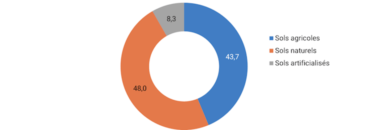
- France's SituationPressure on foreign resources• In mainland France, issues concerning land use changes are different. Unlike the global situation, agricultural land is declining, particularly due to soil artificialisation. However, given its high consumption level, combined with demographic growth, and the insufficiency of raw materials on national territory, France imports large quantities of agricultural and forestry raw materials from deforestation of tropical forests. It thus indirectly uses land located in other regions of the world, and contributes to exerting strong pressure on foreign land resources: resource consumption, loss of natural habitats, carbon loss, etc. • Agricultural land losses in France amount to 35,853 ha, of which 35,780 ha in mainland France between 2012 and 2018Land use by CORINE Land Cover• According to the CORINE Land Cover (CLC) database, in 2018, 59% of metropolitan area corresponds to agricultural land (32 million hectares – Mha), 34% to forests and semi-natural areas (19 Mha) and 6% to artificialised territories (3 Mha). Wetlands and water areas cover approximately 1% of territory. These proportions have changed little since 1990. Agricultural land losses depend on various factors: population growth and urbanised areas, tourism appeal, agricultural decline. Note that agricultural land includes arable land, vineyards, orchards, olivegroves and grassland. However, temporary and permanent grassland are not mapped in CLC. • Between 2012 and 2018, Mayotte is the only region where agricultural land slightly expanded. This is explained by compensation for agricultural land losses due to artificialisation (131 ha) through forest encroachment (532 ha).Land use changes 2012-2018• Over the same period, most land use changes (71%) concern agricultural land, which most often disappears in favour of artificialised territories. Among these changes, 55% affect arable land and 7% permanent crops (orchards, vineyards, olivegroves). • In total, approximately 41,130 ha of agricultural land thus changed use between 2012 and 2018. If we consider reallocations within agricultural land over the same period, the main change is the conversion of grassland to arable land (approximately 6,700 ha). These land use changes can result in increased greenhouse gas emissions (carbon loss) and other environmental impacts (biodiversity loss, etc.). • If in 2017 grassland covers 12.5 Mha, or 44% of utilised agricultural area (UAA), its total area has decreased by 5 Mha since the 1960s. Indeed, increased yields and development of annual forage production have made it possible to reduce areas traditionally devoted to animal feed.Soil sealing• Soil sealing: 6.2% of national territory, approximately two-thirds of artificialised soils • The annual Teruti-Lucas survey, conducted since 1992 by the Ministry of Agriculture on land use and occupation, is based on a physical nomenclature of land use, also accounting for usage. It relies on a sample of hundreds of thousands of measurement points (approximately 1 to 2 per km²). Due to different methods, statistics provided by CORINE Land Cover (complete photograph of French land use taken every six years through satellite image photo-interpretation) and Teruti-Lucas differ. For example, artificialised soils occupy, according to Teruti-Lucas, nearly 5.2 Mha in 2015, or 9.4% of metropolitan territory. Since 2006, these artificialised soils have increased by nearly 600,000 ha, primarily at the expense of agricultural land. • These artificialised spaces cover, for two-thirds, sealed soils, or 6% of national territory. These are mainly non-built soils (surfaced or stabilised soils, essentially roads, car parks, roundabouts, railway lines, storage areas, etc.) and to a lesser extent built soils (essentially low-rise constructions of fewer than three storeys). Artificialised spaces also cover, for one-third, non-sealed soils such as grassed soils on the periphery of buildings (public or private gardens), sports fields and bare soil (dirt roads, building sites, etc.).French forest expands• French forest expands • In mainland France, forest covers 16.9 Mha in 2015. It has grown significantly since the second half of the 19th century with an expansion of 0.64% per year since 1980. This strong growth is explained among other things by agricultural decline and reforestation of agricultural land. The strongest increases concern Brittany, the Massif Central and the Mediterranean region. The forest cover rate in metropolitan France reaches 31%. Mountainous areas are well above this national average, while the North and West have lower forest cover rates (between 12% and 20%).Imported deforestation• France's ecological footprint related to imports of agricultural and forestry raw materials amounts to 14.8 Mha in 2016 • The pressures exerted by the French economy on natural resources are not limited to national territory alone. The ecological footprint measures France's impacts on nature at the global scale, through evaluation of cultivated areas needed for its production and consumption. • According to the WWF, France imports and consumes large quantities of agricultural and forestry raw materials from tropical forest deforestation: soya (4.8 million tonnes), palm oil (970 kilotonnes), cocoa (460 kilotonnes). France's ecological footprint related to these imports represents 14.8 million hectares, more than one quarter of metropolitan area and half of French agricultural area. Approximately 5.1 Mha are located in countries presenting high deforestation risk (Argentina, Brazil, China, Côte d'Ivoire, Indonesia, etc.). • Forests house great species diversity and contribute to climate change mitigation through storage of large carbon quantities. Their role is central in climate change adaptation, soil protection and freshwater supply. Thus, deforestation strongly affects the environment: loss of natural habitats, biodiversity and ecosystem services loss, increased intensity and frequency of extreme weather events amplifying climate disasters, decreased water resources, increased greenhouse gas emissions causing climate warming. • Fighting this "imported deforestation" is therefore a major environmental issue. France defined its modalities within the national strategy against imported deforestation 2018-2030. The latter aims to prompt each actor (producer countries, businesses, investors, consumers) to change behaviour to reduce forest impacts. It seeks to end, by 2030, imports of unsustainable forest or agricultural products contributing to deforestation. • This article is an excerpt from the synthesis report of the 2019 edition of the report on the environment in France.